Friday, September 30, 2016

Durango To Moab

September 27, Durango to Moab - more photos to be added later

We broke down camp, packed up, and headed west.  Our plan was to get as close to Moab as we could but we both had places we wanted to visit along the way.  Ben was into visiting some Indian Sites and Jane wanted to go to the Needles area of Canyonlands National Park. 

We were planning to pass by Mesa Verde National Park but as we approached we noticed a brand new visitor center very near the highway so we stopped in for a short visit – looked at some displays and got a passport stamp.  We have been here twice before and it is always crowded so we moved on. 


  In Cortez we headed north on 491 watching for road CC which led to Lowery Pueblo – the only pueblo that is accessible by car in the Canyons of the Ancients National Monument.  This area of Colorado has a lot of agriculture – corn, alfalfa, and pinto beans.  The ancients (early Indians) settled here to grow corn and beans – and they are still grown here!  At a settlement of Pleasant View we headed west about 9 miles on a dirt road (CC) to find Lowery Pueblo.  It was a stabilized Pueblo which has supported many families and a large kiva with typical north south orientation. The Pueblo had a number of rooms, a Chaco style “T” door,   Jane even hiked a short way to view the Pueblo but opted out on the longer walk to the kiva.  The weather is turning quite warm – long sleeve shirts were shed and sitting in the sun felt great!

Door entry to pueblo

Inside the pueblo

Large Kiva

Back on the road we continued through small towns crossing into Utah. In Monticello we stopped at a Blue Food Market to pick up a few things and a sub sandwich for lunch.  We ate in the parking lot near a family from Poland who were also stopped there in a rental RV camper.  There are many European families in rental units in the campgrounds in Utah.  The young men running the grocery were very clean cut and polite – we wondered if they were Mormons. 
Continuing north towards Moab, Jane convinced Ben to drive the 30-40 miles back a side road to the Needles section of Canyonlands National Park. 
Church Rock - turn here to go to Canyonlands
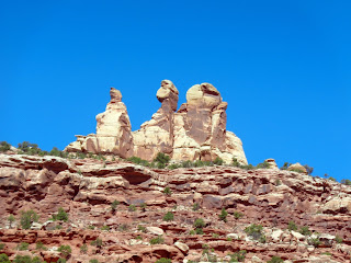
Reading indicated some of the most interesting red rock formations in Canyonlands were here.  We had taken this road a number of years ago as far as Newspaper Rock on a trip where we viewed many, many petroglyphs.  This is an outstanding one very accessible by car.   Ben was not too sure but said OK – off we went for one of the most fantastic 80 miles of any of our western trips.  First 15 miles to Newspaper Rock are nice vista of canyons in the distance.  Then you pass Newspaper Rock area along a small river and enter endless canyons with several hundred foot high red rock walls.  It was beyond anything we have seen and our photos will not do it justice.  There were canyons off the main canyon and it just seemed to go on forever.  Then finally you enter the National Park where there are many formations – toadstools or mushroom rocks, numerous oddly shaped rocks, and what they call the “needles”- narrowly spaced eroded columns of stone.  Sorry to say the lighting was less than perfect for us to get good photos but we did try!  We had considered camping out here one night but chose not to stay with no electricity for a couple reasons.  There is a small national park campground and several national forest campgrounds.  This is a very popular hiking destination with hundreds of trails to explore.  Not for old folks like us – wish we had come here 20 years ago!  Ben agreed he was very glad we had come and even said he thought the formations were the best we had ever seen.  His comment – This will be Monument Valley way in the future!


We drove the road back through the fantastic canyons and stopped to take photos at Newspaper Rock = perfect lighting late in the afternoon!

Ben at Newspaper Rock 


Then back at Church Rock we turned north towards Moab stopping to photograph Wilson Arch.
Wilson Arch

In Moab around 6 PM we got one of the last spots in a packed RV park.  Jane’s research ahead of time paid off – a campground with trees – not the normal thing as we looked at several other campgrounds on the way into Moab.  Tired but satisfied after a memorable day we had dinner, watched NCIS, Bull and went to sleep!   

Thursday, September 29, 2016

Durango CO - unexpected day

September 26, 2016   Durango CO

We were a bit lazy getting up having decided last night we would not take the train back up the mountain to Silverton.  Jane is better but still not feeling great so we reviewed our options for the day and drove east about 40 miles to a new national monument that showed up on our new CO map.  Chimney Rock National Monument was only a couple years old – had been a state park before.  It is an archeological site and tours were only a couple times a day and quite extensive. 


  Jane knew she was not up to a 2 ½ hour tour and Ben chose not to go either.  We hung around the small visitor center talking to the volunteers for a while.  The site is one of the furthest north outliers of the Anasazi from Chaco Canyon which we have visited twice. All these Ancient Indian Sites are linked together. The history was interesting even if we did not get to see the ruins.

We drove back to Durango by a different route passing through Ignacio CO the head of one of the Southern Ute Indians.  They had a huge casino which they say draws lots of crowds.

Back at camp we had lunch and read a bit – I continued to be short of breath off and on with much activity and we decided to visit a “doc-in-the-box”  not too far away thinking maybe it was not all the elevation since we were now down to about 6,000 feet. Maybe bronchitis was our thinking.  After an initial exam, the doctor said “Have to send you on to the ER as we do not have the ability here to rule out a blood clot in the lungs”. Well, that was a bit of a scare – so we drove across town to the ER and got some of the quickest ER care seen by me in some time….arrived at 3:00 and by 3:45 had had EKG, Blood Work, and an Xray.  Then of course you do have to wait for results. Nice nurses and a doc who finally said no blood clot, was combination of sinus inflammation and altitude sickness – each aggravating the other.  Got a breathing treatment, prescriptions for a bronchodilator inhaler, a cortisone inhaler and advice to get down to a lower elevation soon.  Unbelievably they sent us on our way with a “we will send you a bill” and I am sure they will.  Do not think the hospitals at home would do that!  We drove back across town, stopped to fill the prescriptions, pick up some dinner, and drove into the campground just at 7:00 as the Presidential Debate was beginning….we had chosen this campground since it was 1 of 3 that had cable TV and we were planning to watch the debate. 
Two things to comment on – political signs and buying pot in Colorado

First the Pot – we were wondering where they sold it.  The folks here at the campground said to look for the green crosses on businesses.  You just walk in and show and ID and buy what you want.  We saw a clinic down the road from us not too far – then a sign for what looked like a small drug store, and then as we left Durango in a small town a huge flag on a hilltop with a green cross on it…so there are lots of choices for pot shopping.


Second we have now driven about 2,000 miles.  Some interstates, rural and city, and many small towns.   We can count on both hands the number of political signs – and we expected to see lots of both Trump and Hillary Clinton signs.  We have seen 3 Trump billboards (large signs) two were regular billboard type signs and one was a huge hand painted sign on a barn.  There have been 12 yard signs – 6 of them in rural Colorado.  Surprising – we thought maybe they were only spending $$ in battleground states but I thought Colorado was a battleground state.    We have not seen one Clinton sign – well there was one but it was an anti-Hillary sign and I don’t think I want to include what it said but it rhymed with witch.  

A good nights sleep by all after a rather hectic and unexpected day! Tomorrow we leave Durango and head for Moab at a little lower elevation!

Ouray to Durango

September 25 Ouray to Durango

We were toasty warm with our heater and sleeping bags – temperature was down in the 30’s but not the 25 of our coldest night! Cooked and ate breakfast in no rush as we had less than 100 miles to go and wanted to be sure to give any snow on the mountain passes time to melt.  The locals here said if it rained here in Ouray then it would snow in the mountains (ha – we were in what we considered mountains!) if no rain then no more snow.  There was no rain here and the sun was shining so we were quite hopeful for a nice day.  We were in for a treat!


We drove through Ouray and started up towards Red Mountain Pass (11,075) on Rt 555 better known as the Million Dollar Highway – both for the views and the cost of construction.  Information told us there were no guiderails as the snowplows would be unable to clear the road.  Ahead was a formidable mountain known as the Matterhorn – and Ouray is known as the Switzerland of the Rockies…it was a neat little touristy mountain town. 

Leaving Ouray the road was switchback after switchback.  The Sprinter and Ben love driving in mountains – Jane not so much.  The views quickly became as outstanding as promised.  The aspen trees contrasted with the dark green fir trees and the mountain tops were snow covered.  There had been maybe an inch or two of snow the previous day but from the looks of the side of the road – they had quickly plowed it off.  There was no snow on the roads at all but some along the roadside and in the woods.  There were two tunnels and fantastic views just went on and on forever.  


We reached Red Mountain Pass and then descended into Silverton. 

 We stopped in Silverton for more coffee and a short break but did not go into the town as we had plans to ride the train to Silverton from Durango one of the next two days.  We then continued on from Silverton on switchbacks again up and down as we crested 2 more 10,000+ foot peaks.  The views were still outstanding but we felt the views from Ouray to Silverton were the most dramatic. 


Our selected RV Park – Alpen Rose – was about 2 miles out of Durango on Rt 550 so we pulled in about 3:00 and texted our friends that we were meeting in Durango.  They were in Silverton and would stop by as they came back to Durango.  Ben took a nap and Jane caught up on the blog.  The campground was very nice with a courtyard where the internet was excellent.  This campground was completely full – we got one of the last spots because we are short – 21 feet.  They were expecting 52 units to arrive today – two different touring groups.  Wish I had taken a photo at 3 when we arrived and then again about 5! 

Our friends from North Carolina on almost the exact trip backwards from us – came by the campground about 5:30.  We visited a while and then headed into downtown Durango for dinner at the Season’s Restaurant.  The tenderloin was excellent and we had a great time visiting with our friends from Ben’s college days at NC State. The next day they would head east and we would head west in a couple days. Lucky we could plan this mini-reunion!


Saturday, September 24, 2016

Cripple Creek to Ouray Colorado

Saturday September 24, 2016

We woke up at 7:00.  It had been a cold night.  The temperature outside at 7 AM was 25 and inside the Sprinter it was 39.  The one thing we had forgotten was the space heater!  We truly did not expect quite this cool temperatures – I had checked the temps each place and 40’s maybe but not 20’s!  We were not too uncomfortable in our sleeping bags with long sleeve shirts but it was too cold for cooking etc….we broke camp in 15 minutes and were on our way back down the mountain to Florissent where we had hopes for finding coffee and some breakfast.  And did we ever find a good breakfast!  Costello Street Coffee House!  We split biscuits with sausage gravy, a cinnamon roll, and a blue berry scone – they and the coffee were great – not sure if it was us being so hungry or the food….I think it was both.  Restaurant was an old farm house – most of the downstairs rooms were furnished with antiques – the one we were in had an entire wall of tea pots on beautiful shelves.  And the tables and chairs were all old as well…you ordered at a counter where they displayed all their fantastic baked goods and then they brought out your food.  Great second start for the day.
Cinnamon Roll

Biscuit with Sausage Gravy

All the goodies we did not eat!
We headed west on US 24 to Buena Vista and then US 50 through quite a number of small towns on our way to Gunnison.  We crossed what I describe as high plains – lots of cattle, baled hay, and farms.  We saw quite a number of antelope.  Always ahead were the Rockies and there was snow.  The aspen in the snow was certainly beautiful.  We crossed Monarch Pass at 11,312 feet. The road was clear but the parking lot where we stopped to take a photo was still icy.  The scenery continued to be outstanding as we continued to Gunnison. 

Mountains to the West
We began to see snow!

And more snow on the peaks

At Monarch Pass - 11,312 - Continental Divide


In Gunnison we made a Walmart stop – for all the things we needed – a small heater, WD40 for a squeaking door, Windex since we have used ours up cleaning off bugs, and some eggs.  If you continued north from Gunnison you would reach the well-known ski resort – Crested Butte.  We headed south since we need to be in Durango on Sunday to meet Ben’s college roommate.  From Gunnison we headed west to Black Canyon of the Gunnison National Park.  We traveled along the Blue Mesa Lake that had been formed by a dam on the Gunnison River.  It was a huge lake at 7,000 to 8,000 feet elevation. However with the overcast sky and low temps today few people were out enjoying the water!

Blue Mesa Lake
When we reached the park we viewed their film, got a passport stamp, got Daniel a post card, and spent some time at a couple overlooks looking down into the gorge.  This river carved a very deep canyon in the rock – about 2,000 feet– the canyon remained unexplored until well into the 1900’s. 

Black Canyon of the Gunnison

Black Canyon of the Gunnison

The patterns in the walls of stone were facinating
A few miles west of Black Canyons of the Gunnison is Montrose.  Montrose was probably the largest town we visited today. We joined US 550 south to Ridgeway and then Ouray.  Ouray is known as the Switzerland of the US and it is indeed again in the Rocky Mountains at 7,792 ft elevation!  We had planned to stop at the KOA and it is on the north of town. 


approaching Ouray - it is really gray and gloomy!

Ben with his TV set up watching something - with heat!
We had had a wonderful day even with a bit of a rocky start!  Glad though to be stopped where we could climb in the Sprinter, set up the TV, plug in the new heater, and cook supper.  If you have read our blog before you know our Sprinter Van allows us space for about anything – but only one thing at a time. You can lounge, cook and eat or you can sleep – comfortably but not at the same time.  Our late afternoon - evening was of the lounging and eating mode. A first for us – Jane baked corn muffins to accompany our canned beef stew.  It surely did taste good!  Maybe that was because with our huge breakfast all we wanted for lunch was cheese crackers! 

Caught up on the blog even though the internet connection did not allow for posting photos.  The weather forecast maybe calls for snow – if so our departure may be delayed a few hours tomorrow as we must cross three 10 - 11,000 foot passes. They say if it rains here in Ouray, it will snow in the high passes.  The road from here to Durago is known as the Million Dollar Highway – both for the views and the cost of building it!  It closes for ice… so we may not be leaving here until noon or so…..time will tell.

Cripple Creek Colorado

Friday September 23, 2016
Cripple Creek Colorado

Good Connection now but lighting is terrible- hope I have picked the right photos!

Today we deemed an explore and rest day.  I cooked a fairly decent breakfast of toasted English muffins, grits, and bacon and of course coffee!  Feeling some better after a great night’s sleep.  We reviewed our options for exploring and decided to visit the Heritage Museum to learn about the history of the mining and railroads and then drive the Gold Mine Loop to Victor and back to Cripple Creek.  It was beautiful clear blue and the aspen were breathtaking.  There was a Festival being planned for the weekend so the entire downtown area was blocked off.  Downtown Cripple Creek is a restored theater, lots of shops, a few restaurants and LOTS of casinos. 

Looking down to Cripple Creek

Aspen View


The Heritage museum was on the far side of town from our RV Park and when we arrived the view was almost beyond description.  To the west were rocky mountain peaks as far as you could see north to south.  To the east were remains of old gold mines and the terraced land from the current day mining operations.  The mining operations in the late 1800’s and early 1900’s put the Pikes Peak area on the map. Many a man made his fortune here and many more lost.  The mining continued for many years and gradually slowed until in the 1990’s the remaining gold mines were consolidated and today surface mining under the Cripple Creek and Victor Mining Company. This is a part of a large company- Newmont- that as an aside we own stock in!  They have very stringent regulations and from the looks of things are returning the land to as close to what was there before as possible.  The ore is surface mined, trucked out, crushed, and processed to recover the gold. Ben remembers the recovery rate of 360 ounces of gold per ton of ore.
Old Gold Mine

Working Cripple Creek and Victor Surface Gold Mining Operation


We viewed the old and new mines.  Tours of the surface mining site closed on Labor Day – it would have been very interesting.  Having been underground in a Copper Mine in AZ we opted out of going down in one of the old Gold Mines.  The drive through the mountains to Victor and then back to Cripple Creek was beautiful
View to the West

Aspens

Ben beside tire from one of the Ore hauling trucks

We returned to camp, had lunch, read, did some internet surfing, wrote and posted the blog, cooked supper, watched a movie – in other words did quite a bit but not a lot of anything!   Jane felt some better today but not 100%.  I think I mentioned yesterday our RV park - Hospitality House - was behind a Bed and Breakfast that is the restored Teller County Hospital.  Got a photo today. 

Hospitality House B & B - Old Teller Co. Hospital