Wednesday,
June 06, 2012
A grocery
stop and a post office stop were on our agenda before we left Cortez. We are
not certain how long we will be staying in Chinle at Canyon de Chelly and then
at Chaco Canyon. Both are campgrounds with limited facilities and if there is a
grocery in Chinle it would be very expensive…so a stop was essential. The other thing we did was try to identify a
restaurant we have eaten at every time we have been in Cortez – well we found
it and now it is a bar.
We headed
south out of Cortez to Shiprock, New Mexico. South of Shiprock we were going to
take Navajo (Bureau Indian Affairs) 13 across the Chuska Mountains. We had a map once that listed the
10 most beautiful roads in the Navajo Nation – we still have them marked on a
map and have managed to drive on over half of them over the years. Jane was a
bit afraid of a bad road until we passed a small tour bus stopped near Shiprock
Peak for the tour participants to climb on the unusual rock formations near the
road. She was fairly sure a tour bus was
not taking an unpaved road.
 |
| Shiprock |
 |
| Busload of Tourists climb rocks |
The drive
was indeed beautiful. Much of the Navajo Reservation (called the Navajo Nation
by the Navajo) has minimal vegetation but this mountain range right through the
center of the area includes a bit of everything. The lower elevations are
primarily desert vegetation but you are so struck with the domination of
Shiprock Peak that you hardly notice anything else. At 7,106 feet the peak
dominates the landscape for miles around where the general elevation is 4,000 –
4,500 feet. Rt 13 skirts south of
Shiprock Peak and heads west crossing from New Mexico into Arizona. The Navajo Nation includes parts of Arizona,
New Mexico, Colorado, and Utah. We are using a map of the Four Corners area
that is available from AAA. It is much better than having to go back and forth
between the various state maps.
As we cross
into AZ we begin to climb – through red rock, through grey and white rock,
through pine forests and even at the very top aspen trees. As you begin to climb there is signage that
the road is not maintained in the winter.
Passing through several small villages we finally climbed and then
decended the Chuska Mountains - we were at Buffalo Pass at 8,441 at 12:30 PM
and it was 69 degrees. The sky was so blue and the mountains so red – it was
indeed a beautiful sight. We stopped at a pull-off partway down the west side
of the mountain range to enjoy lunch. We
saw few homes through the high part of the mountains – but many roads with gates
indicating there were summer locations – we did see sheep and some cattle that
had perhaps been brought up for the cooler temperatures and better grazing.
 |
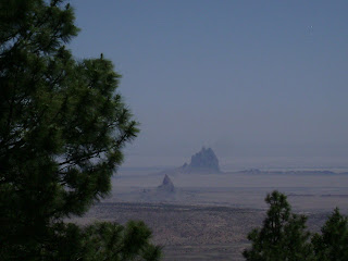
| Shiprock in distance from Mountains |
 |
| Our Lunch break view |
Ben says to
note there were several curves and down sections of the road that were notes to
be 14% grade and 10 MPH. He says no
engineer ever builds a road with that grade – but this one is certainly that.
The curves equaled any we have seen on the trip – sure glad I was not in that
bus if it came this far! The road however was very good blacktop road and aside
from having to drive slowly it was very pleasant. From the peak we could make out Shiprock Peak
in the distance but doubt the photos we tried to take turn out.
Road 13
ended at Rt. 12 which took us south to the turn off for Canyon de Chelly
National Monument. Towns throughout the
Navajo Nation are primarily small. One
interesting thing about the homes is that most but not all are built with a
house for living and a Hogan (8 sided structure) for native ceremonial
purposes.
 |
| Hogan and Mobile Home |
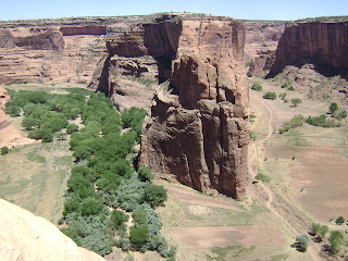
Along the
north rim of Canyon de Chelly are 3 turnouts where the National Park Service
has built overlooks to allow views down into the canyon. The overlooks would be
necessary as the cliffs surrounding the two canyons are around the valley are
800 – 1,000 feet high in most places. Near the south end near Chinle there are
some much lower walls and this is where access is easier into the canyon. People are thought to have lived in this
canyon longer than anywhere else on the plateau. Families still live and farm
in the canyon today but most families with children have moved to the rim to
allow their children to attend school.
Tours are
available into the canyon and we had been considering one. About 10 days ago
one of the tour trucks overturned and fell causing one death and several
serious injuries. Jane had been reading a blog written by a couple traveling
this area for several weeks – ironically they were on the tour that had the
fatal accident. In following the blog
over the past week these two folks are recovering but the Park Service has
halted tours into the canyon until the investigation is complete. It is thought
one of the pins that held the wheels in place broke causing the driver to be
unable to steer the truck. Anyway – we
are not touring in the canyon this trip.
 |
| View into Canyon de Chelly |
 |
| A Really tough trail |
We did visit
all the overlooks – Ben getting much better views than Jane. The heights were
more than she could handle - with the canyon not very wide it is difficult to
see into the depths without getting closer than she is comfortable. The day was beautiful, clear and a bit windy
but Ben got some great photos.
The visitor
center had a nice film and Ben had a long and enjoyable conversation with a
Navajo gentleman who was a silversmith. He was set up there in the visitor
center showing his jewelry and had all his tools there with him. He has some very exquisite work which was not
at all like most Navajo jewelry. Ben was thrilled with the conversation and
said it was worth this part of our trip to talk to this gentleman.
We drove a
short distance further to the Cottonwoods Campground. This campground is under a canopy of huge
cottonwood trees. It is June but it
literally looks like it is snowing here right now. The cottonwoods are in bloom
and small seed pod with white fluff is falling like snow! With the wind and the
sunshine you can see hundreds of them flying through the air. The ground is
white in some areas where they are collecting.
There are many Cottonwoods Campgrounds in this country – but this one
truly deserves the name!
We selected
a site and paid our $10 – cash no checks or credit cards – to the Navajo
rangers. This campground is now managed and run by the Navajo Nation. It has no hook-ups but has nice level paved
sites and very clean bathrooms. The campground takes no reservations but as I write
this at 8:15 it looks like nearly every site around us is full.
 |
| Campsite at Cottonwood in Chinle |
 |
| Cottonwood "Snow" |
I hauled out
the Coleman stove and cooked Ben some fried pork chops for supper. We do not
have much room in the small refrigerator so I do not carry fresh meat. I think
he had gotten tired of canned meats so this was a surprise from the morning
grocery shopping!
We just had
a conversation with folks in a Sprinter that pulled in across from us. This is
their 1st night ever camping in their vehicle! It is cool and very
peaceful here so we expect a good night’s sleep!


No comments:
Post a Comment